Open Transit Indicators
Jump to navigation
Jump to search

| This page still requires some edits, it has been added to Leeor's edit queue |
| Vendor | World Bank Azavea |
|---|---|
| License | GNU General Public License |
| Documentation | https://github.com/WorldBank-Transport/open-transit-indicators/blob/master/2015_01_20_OTI_UserGuide-rev3.pdf |
| Data Input | GTFS, GIS shapefiles, TransitTime, OpenstreetMap |
| Data Output | maps, accesibility and performance statistics |
| Website | https://github.com/WorldBank-Transport/open-transit-indicators |
Open Transit Indicators (OTI) is a tool offered by the World Bank that allows public transit administrator measure performance and accessibility of their systems, quickly and easily sketch in new lines to adjust a transit system, and visualize side by side comparisons of the performance and accessibility of the base case and the scenario. The user can specify a broad population category (ex. total population, working age population, school age population), a population subsection (ex. low-income, race, etc.), and a destination (ex. jobs, school, medical centers).
Indicators
The following indicators are available through OTI [1]

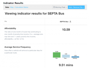
Example of indicator output for the SEPTA bus system.
Source: https://github.com/WorldBank-Transport/open-transit-indicators/blob/master/2015_01_20_OTI_UserGuide-rev3.pdf
Source: https://github.com/WorldBank-Transport/open-transit-indicators/blob/master/2015_01_20_OTI_UserGuide-rev3.pdf
| Indicator Name | Description |
|---|---|
| Affordability | The ratio of one month of round-trip commuting to one month of poverty-line income. If a = average one-way fare and i = yearly poverty-line income, affordability = (a*42) / (i/12). (The data used by this indicator is input by the user, not pulled from GTFS.) |
| Average Service Frequency | How often a vehicle will arrive at a particular stop for a particular route. |
| Distance Between Stops | The average distance between stops, per route and mode. |
| Length | The sum of the total length of each route in the transit system. This indicator does not account for road or rail shared by multiple routes. |
| Number of Modes | Total number of different transit modes in the system. |
| Number of Routes | Total number of routes in the system. |
| Number of Stops | Total number of stops in the system. Stops shared by multiple routes are counted only once. |
| Stop Density | The number of stops per kilometer of a route. |
| System Road Coverage | The ratio of transit system length to the length of the road network. This indicator accounts for multiple routes sharing the same roadway. |
| Time Traveled Between Stops | Average amount of time traveled between subsequent stops along a route trip. |
| Weekly Number of Hours of Service | The number of hours per week that the system provides service. |
| Network Density | An index value: the total length of the transit network in comparison to the total area of the urban area. |
| Ratio of Suburban Lines | The ratio of lines operating outside the urban area to the lines operating only within the urban area (based on urban boundary data provided under the Settings tab). |
| System Stop Coverage | The percent of the urban area that is within the configured distance from stop locations. |
| Job Accessibility | The number of jobs vs. the number of individuals who can reach a job location (destination metric) within the configured commute time. |
| Population-weighted Service Frequency | Average service frequency adjusted by the number of individuals within the configured distance from stops. More frequent service in areas of high population would result in a higher metric. |
| Population-weighted Service Frequency (2) | Population-adjusted service frequency for the secondary population attribute. |
| System Accessibility | The percentage of the population metric 1 that is within the configured distance from stops. |
| System Accessibility (2) | The percentage of the population metric 2 that is within the configured distance from stops. |
| Dwell Time Variance | The average variance in minutes of dwell time (requires observed stop times). |
| On Time Performance Variance | The average variance in minutes of arrival time (requires observed stop times). |
| Regularity of Headways | The average variance in minutes of headways (requires observed stop times, which come from the uploaded GTFS data). |
Screenshots are shown below.
References
- ↑ Open Transit Indicators End Users’ Guide. rev 3: 20 January 2015. https://github.com/WorldBank-Transport/open-transit-indicators/blob/master/2015_01_20_OTI_UserGuide-rev3.pdf


