File:Livabilityvision.png
Jump to navigation
Jump to search


Size of this preview: 395 × 600 pixels. Other resolutions: 158 × 240 pixels | 718 × 1,090 pixels.
Original file (718 × 1,090 pixels, file size: 783 KB, MIME type: image/png)
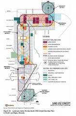
This land use diagram for Las Vegas's North Fifth Street Corridor Plan is an example of the type of document that can be developed during the visioning process. Source: Transit Cooperative Research Board
File history
Click on a date/time to view the file as it appeared at that time.
| Date/Time | Thumbnail | Dimensions | User | Comment | |
|---|---|---|---|---|---|
| current | 22:49, 11 November 2016 | | 718 × 1,090 (783 KB) | Rabiabonour (talk | contribs) | This land use diagram for Las Vegas's North Fifth Street Corridor Plan is an example of the type of document that can be developed during the visioning process. Source: [http://www.trb.org/Publications/Blurbs/174953.aspx Transit Cooperative Research Bo... |
You cannot overwrite this file.
File usage
The following page uses this file: